Update on project progress
The Biokarelia partners gathered together via Teams to go through the progress and finalize the common plans for 2022.
The Biokarelia project will continue until the end of October 2022
Due to Covid-19 pandemic the Biokarelia project has had some challenges in reaching its goals in the original schedule. Due to this, extension for the project was applied. The extended implementation time will allow the partners to deliver all the outputs.
However, regardless of the continuing pandemic during 2021, many underlying (not so visible) project actions have progressed.
Last year the lead partner Natural Resources Institute Finland collected forest fire data from Russian and Finnish side, assembled it to a common data base and looked into how the data could be made comparable. On the Russian side the data has been in a paper form. The Forest Research Institute of the Karelian Research Centre continued to digitize these paper records of historical forest fires on Russian side last year. The aim has been to cover timescale from the 1990's to 2021. Kostamuksha Strict Nature Reserve took part in finding the data from archives. This year an analysis of the data (i.e. spatial patterns and grouping in space by type of the fires) will be done and it will aid at creating the fire forecasting model.
Natural Resources Institute Finland also bought new laser scanning device. The accuracy of it is quite remarkable, as 500 points/m2 can be reached with it. "It's practically a microscope for forest research" tells the project leader Evgeny Lopatin. The device can be placed on a drone, a car or even a back bag. The device was tested in different environments to calibrate it and the research plots established in the project also last year were visited and scanned with the laser scanner. "With laser scanning you get direct measurements and can create a digital twin of a forest" says Lopatin. This technology allows detection of deadwood and the location of the deadwood combined with the data from multispectral cameras (also used in the project) allows to detect the present moisture and temperature of the dead tree trunk. This is relevant to one of the main aims of the project which is to develop a forecasting model forest fire.
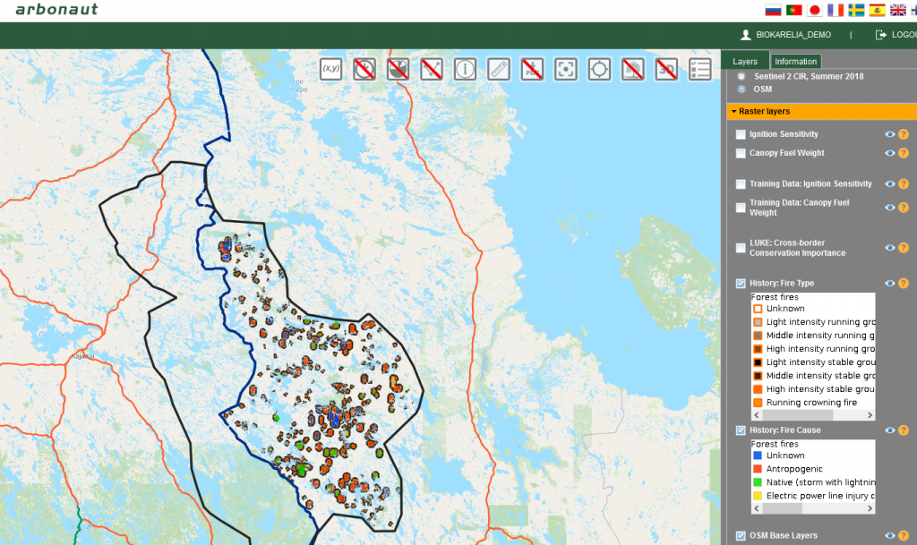
View of ProMs platform showing the fire type and history data from Russian side.
The data collected by other partners and now in digital form was last year published in the ProMs by Arbonaut Oy Ltd. Arbonaut ProMS (Project Management System) is a platform that can be used for hosting various kinds of geospatial information. Arbonaut also added fuel load data in the platform. The tool shows fuel paths, canopy fuel load and ignition sensitivity helping to estimate where a forest fire may cross the border and aid in managing those fires. Currently, Arbonaut is focusing on analyzing canopy loss from Sentinel images. This is relevant, as harvesting creates grasslands that can have increased fire risk. Thus, the intensity of forest management will be connected with fire risk.
Centre for Economic Development, Transport and The Environment for North Karelia focused last year on meeting biodiversity experts to build a network. That will continue this year and a new project planner Philippe Fayt will mainly focus on this action as well as preparing the webinars and workshop that is coming in the autumn 2022.
In the coming spring more information on the action and results of the project will be shared in webinars. The coming webinars will continue the webinar series of Biokarelia project (see recordings of the previous presentations in YouTube). The next webinar will take place 16th of March and focus on Available tools for assessing forest habitats, estimating fire risks, and forecasting future changes. Register and see the programme in Webropol.